In the dirty north flow behind the last cold front, yesterday had problems clearing the clouds, resulting in overcast skies, cold temperatures, and breezy conditions. High temperatures in the Upper-Midwest ranged from the low-50s to 60.
My weather station recorded the highest temperature at midnight, as temperatures fell throughout the day. Afternoon temps were in around 52 degrees.
 Yesterday's numbers:
Temps: 50.2 / 65.6
Dewpoints: falling sharply, from 65 to 45
Barometers: 29.74 rising to 30.04 "Hg
Windgust: 13 WNW at 14:00

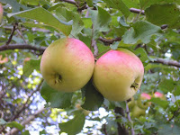
(Left) are some apples in the trees growing in the yard. (Right) are cirrus clouds invading the region, taken this afternoon.
A high pressure (1020mb) drifted across the region last night and this morning. Clouds finally broke up before dawn this morning. Late this afternoon a trough of low pressure is moving west from the Dakotas. Winds are returning to a southerly flow head of the approaching wave, allowing temps to reach 60s in most areas.
 Today's numbers:
Temps: 37.8 / 60.2
Dewpoints: between 36 and 46, rising
Barometer: peaking at 30.10 "Hg, then falling
Windgust: 14 mph WNW at 01:50
The trough is triggering areas of rain and thunderstorms, and will be approaching the region overnight. Rainfall is not expected to be heavy and will end tomorrow morning.
No comments:
Post a Comment