29. Bits & pieces: Great Lks Water Compact, U-COOP, La Nina, Hi-Res Radar.
I found an article explaining the Legislature's vote yesterday in Ashland's Daily Press online.
"All eight Great Lakes states must approve the compact and Congress must ratify it before it can take effect. Illinois, Indiana, Minnesota and New York have signed the treaty into law. Quebec and Ontario also have approved it. Michigan, Ohio and Pennsylvania have yet to sign off on the deal."
Five days ago I began reporting as an unofficial observer to the National Weather Service (NWS) Cooperative Observer Program (COOP). OSNW3 has a nice blurb about COOP on his website. Reports are compiled daily from around Wisconsin and can be found every morning around 9:00 on this page, provided by the NWS in Milwaukee.
To mark my beginning in the program, I clipped two of my reports from the daily list (to the left) from yesterday and today. No precipitation here, but warm days and cool nights.
La Nina continues, although weakening.
After a moderately strong La Nina in the winter months of 2007/08, La Nina is now fading away. (Current ENSO discussion from Australia's Bureau of Meteorology here). The official forecast calls for the water temperatures to in a neutral state through at least the next several months.
This map (to the right) is from the Climate Prediction Center (CPC), the top shows water temperatures on 7 May 2008 and the bottom shows how these temperatures differ from average - very little. The reason I bring up current El Nino Southern Oscillation (ENSO) conditions is because NWS Milwaukee has an article exploring links between La Nina and the severe weather season in Wisconsin.
The conclusion is not clear: strong tornado outbreaks have occurred in La Nina years, but it seems La Nina usually suppresses severe weather.
Here is a summation quote from their article:
"... based on the statistics from 1970 to 2007, if there are sea-surface temperature anomalies at or below -0.5C in the Niño 3.4 region, historically it corresponds to an 83% chance of a below average number of tornadoes in the state, or 5 to 1 odds of a below average year."
Coming off of a La Nina winter, we have a 83% that this year will be a below-average year for tornadoes in Wisconsin. The average number of tornadoes in any given year for Wisconsin is 21.
However, there is a caveat (isn't there always?): Just because the statistics above indicate a historical trend for La Niña years to produce below average numbers of tornadoes in Wisconsin does not mean that you should let your guard down now. There have been significant tornadoes in La Nina years, the F3 tornado in Siren in 2001, an F4 tornado in Fond du Lac and Winnebago counties in 1974, and seven F3 + tornadoes in 1985.
Upgrade coming to WSR-88D radars.
NWS Milwaukee will be the first in the region to be upgraded, scheduled for May 24th. The other NWS Offices should be upgraded in the coming months.
I skimmed through the PDF document discussing the upgrade and found a few obvious improvements that will be of immediate benefit.
1) Resolution will be increased from the current 1 km (0.62 mi) to 0.25 km (0.155 mi). This will increase the resolution of the radar products by a factor of four.
2) The radar's range will increase from the current 124 nm (142.7 mi) to 162 nm (186.4 mi). This will allow more complete coverage between radar sites, filling in data-gaps with more information.
The example images (above) are from the PDF and show the difference between the current capabilities (left images) and the new high-resolution upgrade (right images). Radar products should become more detailed and clearer, allowing radar to give a better view of storm characteristics.
Of course, there is a caveat with this too: The new high-resolution will not be available on the NWS radar websites due to bandwidth limitations. It may be some time before the new product will be available to the general public.

 U-COOP: WBRW3
 La Nina continues, although weakening.
  Upgrade coming to WSR-88D radars.
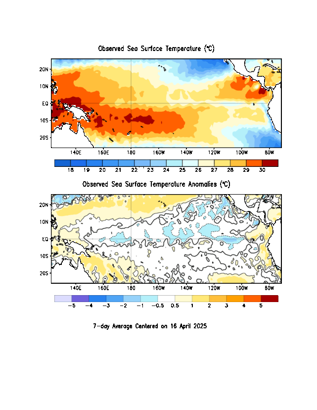