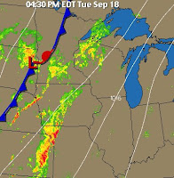
 A slow moving low pressure pumped up warmth from the south before dragged a cold front across the region, bringing rain and some storms.
 Monday saw some thunderstorms and rainshowers at dawn as the low pressure continued to approach, electricity even flickered off after some nearby crashes of thunder. Light sprinkles continued on and off all day as showers moved across the region.
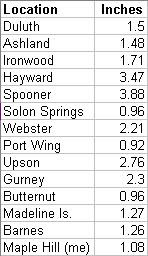
 In the early evening hours the cold front began slowly edging eastward, triggering heavy rains NW of Duluth. A tornado was sighted by Law Enforcement outside of Grand Rapids and Flash Flood Warnings were issued after 5 to 6 inches of rain fell across that area. Here on the hill the rain increased from sprinkles to heavy showers with the heaviest occurring around midnight and then before dawn on Wednesday. Winds increased after midnight as the cold front moved through, beginning to usher in drier air.
 This system was able to pump up warm air from the south, a pleasant change after last week's freezing temperatures. This means we're having Indian Summer! I hope this hangs on for another month. Either way, we're finally getting much needed rain. As of Sept 19th, we have now received 40% of normal rainfall for the month. That beats the 30% of July!
 Currently @ 14:45:
 The chart (right) shows the high and low temperatures of the last five days, Friday through Tuesday. Saturday morning was our first freeze with a temperature of 30.1. This is a nice display of how temperatures have rebounded after such a harsh cold snap.
Labels: climatological data, current conditions, highs/lows, pictures, rain, rainfall numbers, yesterday's numbers
30. 31.